Mandli X-35

Mandli’s future-focused data collection vehicle was designed with you in mind.
X35 collects highly detailed, geolocated pavement and asset data,
simultaneously streamlining and automating processes.
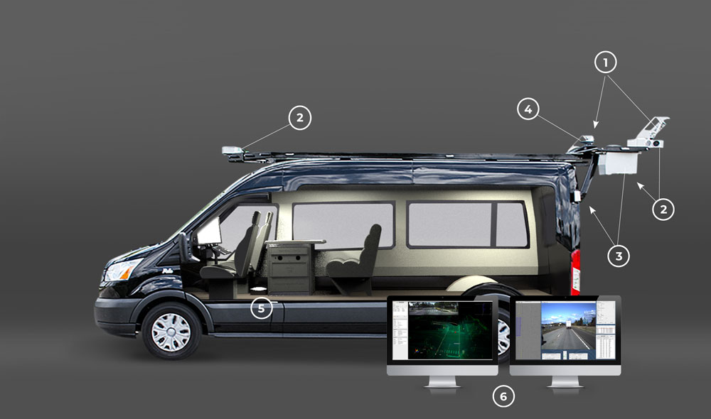
1 Dual Velodyne HDL-32 LiDAR sensors collect high-definition, 3D representations of the surrounding environment. LiDAR coverage makes for a “real-world” 3D view allowing inspection of assets in an accurate virtual environment without the need to travel to remote sites.
3 Dual LCMS Pavement Scanners, with a resolution of .025 mm/.05 mm, provide automated crack detection and distress classification across the entire width of the lane, making pavement upgrade projects easier and more effective.
5 Advanced independent Power System offers a factory installed High-Output Alternator and two factory batteries. This eliminates the need for a generator, and allows the system to operate independently and safely.
2 Nine 8.9 MP Cameras deliver nearly 80 megapixels of a 360° image. This means inspection of road conditions and asset locations without the need to travel to remote sites. The simultaneous use of LiDAR and Photolog provided from our cameras guarantees the most accurate data possible.
4 Position Orientation System includes high quality Inertial Measurement Unit (IMU) and Optical Distance Measurement Instrument (DMI) which allow for accurate mapping of assets and their geographic coordinates regardless of obstructions.
6 Processing/Post-Processing Software is provided to our customers with customization and support so you can get the most out of the data collected. The same easy-to-learn software is used in-house at Mandli.
Calculate Your Storage Requirement
Frames per mile:
LCMS Resolution:
Number of Cameras:
Requrement:
5.80 GB/mile
*200 Frames per mile + 2 mm LCMS Resolution recommended
Industries include DOTs, municipalities, airports, construction companies, engineering firms, utility companies, and Emergency Services. With projects spread across the United States and beyond, Mandli vehicles can meet the challenges of any data collection project.
- Urban Modeling
- Roadway Asset Inventory
- Utilities Asset Inventory
- Intersection Modeling
- Asset Encroachment
- Right-of-Way Imaging
- Pavement Distress Analysis
- Laser Digital Terrain Mapping
- Sign Retroreflectivity Data
- HD Vector Maps for Autonomous Driving Platforms
- Pavement Data
- Curve and Grade
- Overhead Sign Data
- Vertical and Horizontal Clearances
- Engineering Planning
- Next-Generation E-911
“All companies speak of the importance of customer service. Mandli epitomizes customer service. It has been a pleasure to be associated with Mandli and work with the many individuals of this company from the owner, project manager, business lead, and production managers.”
-Utah DOT

