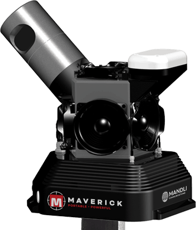

MAVERICK is a portable, powerful, and proven spatial data collection system. Combining high-resolution 360º imaging, high-definition LiDAR, and an integrated position and orientation system, Maverick is capable of efficient and accurate mobile data collection. The vehicle-mounted system is able to operate in a wide range of conditions and can be utilized for projects of any size and scope. System operation is simple and intuitive, requiring only one person to collect and review the data. The included collection software features real-time component feedback and data viewing functionality, allowing for data to be easily collected and quality checked in-field. Maverick also comes packaged with robust viewing and asset management software for putting your data to use.

Portable

Powerful

Proven

Planetary
Maverick in Action
Learn more about every piece of Maverick and how they come together.
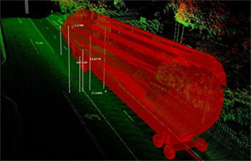
Maverick LiDAR data collected in Madison, WI.
Actuated Mount Installation: One person can quickly and easily attach a standard roof-top mount, secure Maverick to the mount, and initialize software for collection.
LiDAR and 360º images collected by Maverick can be imported into Orbit GT's suite of Mobile Mapping software.
Discover the intricate process of applying the Maverick logo to each system enclosure.
Working with the City of Madison, Maverick collected LiDAR data on the Capital City Bike Trail to look for flaws in the pavement, encroaching plant life, and other assets.
Mandli used the Maverick when working with WholeTrees and the City of Madison to identify entire trees to be used in the construction of Festival Foods on East Washington in Madison, WI.
Sidewalk data is often difficult and costly to collect. With the Maverick on a Segway, the sidewalks downtown and around the capital building in Madison, WI are easily collected.
The Mandli team traveled to California to make a proposal suggesting the use of the Maverick as a source of original material to create computer graphics for the movie industry.
One of Maverick's early projects was helping the Wings of Dreams Museum transport a large space shuttle fuel tank to their facility. The goal was to make sure that the tank could be safely transported without coming into contact with any objects next to or above the roadway.

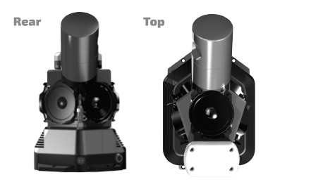
Maverick Features

LiDAR
Velodyne HDL-32 LiDAR sensor collects high-definition, 3D representations of the surrounding environment.

GPS
NovAtel SPAN-IGM-S1 Global Positioning System provides accurate location information.

Cameras
Ladybug5 spherical imaging system captures high-resolution images using six high quality 5-MP sensors.

Hard Drives
Removable hard drives store the collected data in a compact format.

Wireless Control
Maverick is controlled wirelessly through WIFI connection. The Maverick data collection interface can be accessed by any device with a WIFI connection.

Easy Mounting
Maverick can be easily mounted on a wide range of vehicles, and can be both installed and removed by a single individual.


Maverick Specifications
| System | |
|---|---|
| Operating Temperature | 32º to 110º F (0º to 43º C) |
| Power Supply | 12V – 36V DC |
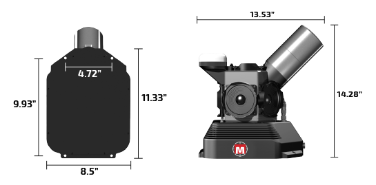
| Dimensions | 13.53” x 8.50” x 14.28” (34.4cm x 21.6cm x 36.3cm) |
| Weight | 19.5 lbs (8.85 kg) |
| Mount | Mount bolts to existing roof racks (four 1/4” screws) or quick release vehicle mount options available. |
| Laser Component(s) | |
|---|---|
| Type | Velodyne HDL-32 |
| Laser/Detector Pairs | 32 |
| Vertical Field-of-View | +10° to -30° |
| Horizontal Field-of-View | 360° |
| Accuracy | 2 cm (one sigma at 25m) |
| Output | Up to 700,000 points/second |
| Safety | Class 1, eye-safe |
| Imaging Component(s) | |
|---|---|
| Type | Ladybug 5 |
| Megapixels | 30 MP (5MP × 6 sensors) |
| Imaging Sensor | Sony ICX655 CCD × 6, 2/3″ |
| Optics | 6 high-quality 4.4mm focal length lenses |
| Field-of-View | 90% of full sphere |
| Spherical Distance | Calibrated from 2m to infinity |
| Focal Distance | ~200cm. Objects have an acceptable sharpness from ~60cm to infinity. |
| Positioning Component(s) | |
|---|---|
| Type | Novatel SPAN-IGM-S1 (novatel.com) |
| Integrated Software | |
|---|---|
| Collection and Viewing | Real-time web-based data display and feedback; moving map display; accessible by any device with a WIFI connection. |
| Distillery | Image, LiDAR, and GPS post-processing software; flexible data format output that can be imported into third-party cloud and asset management software. |
| Shipping Case | |
|---|---|
| Type | Durable, custom-designed shipping case |
| Dimensions | 22″ × 18″ × 10″ (55.9cm × 45.7cm × 25.4cm) |
| Shipping Weight | Under 40 pounds (18.14kg) packed |
Maverick Applications

Transportation Safety
Transportation safety prevents accidents, saving lives and avoiding injuries. Maverick can be used to collect data on the following safety risks: guard rails and end treatments; rumble strips; paint striping; sign sheeting condition assessment; intersections; clash detection; public safety and ADA compliance issues; and many more.

Construction
Maverick provides a solution for communication and documentation throughout the construction lifecycle from pre-planning, design, site preparation, through to the finished outcome.

Roadway Assets
Maverick’s collected 3D point cloud provides an inventory of assets and their condition allowing for easy asset management, maintenance, and repair. Common roadway assets include clearance measurements, oversized vehicle routing, road surface area, streetlights, power poles, sign inventory, and many more.

Utilities
Maverick can help manage utility assets such as utility poles, transformers, primary and secondary power sources, distribution lines, transmission lines, vertical clearance, and vegetation encroachment.