Mandli Applications
Urban Modeling
Mandli's LiDAR data collection system is an excellent tool for providing accurate models of urban areas. These models can be used to plan improvements, inventory assets, and evaluate civil concerns.
Asset Inventory
Mandli's LIDAR, imaging, and positional data is used to extract relevant assets from collected highway data. All assets can be referenced to the GPS and right-of-way imaging data.
Intersection Modeling
Railroad and street intersections can be some of the most dangerous areas on the road. Using our LiDAR and imaging systems, Mandli reproduces realistic and accurate representations of these intersections.
Asset Encroachment
Power lines are often a difficult, time consuming, and hazardous asset to inventory manually. Power lines and surrounding vegetation can be automatically catalogued with Mandli's LiDAR data collection system.
Right-of-Way Imaging
Mandli's right-of-way imaging system is capable of recording digital images and data in a variety of weather, speed, and lighting conditions. The imaging software controls data collection with real-time image viewing, camera controls, GPS data, route setup and management features, and DMI calibration and operation.
Curve and Grade
Mandli's positional system uses differential GPS and an inertial measurement unit (IMU) to extrapolate road geometry such as curve, grade, and cross-slope. The vertical grade (slope) and horizontal grade (cross-slope) are standard outputs from Mandli’s POS LV system.
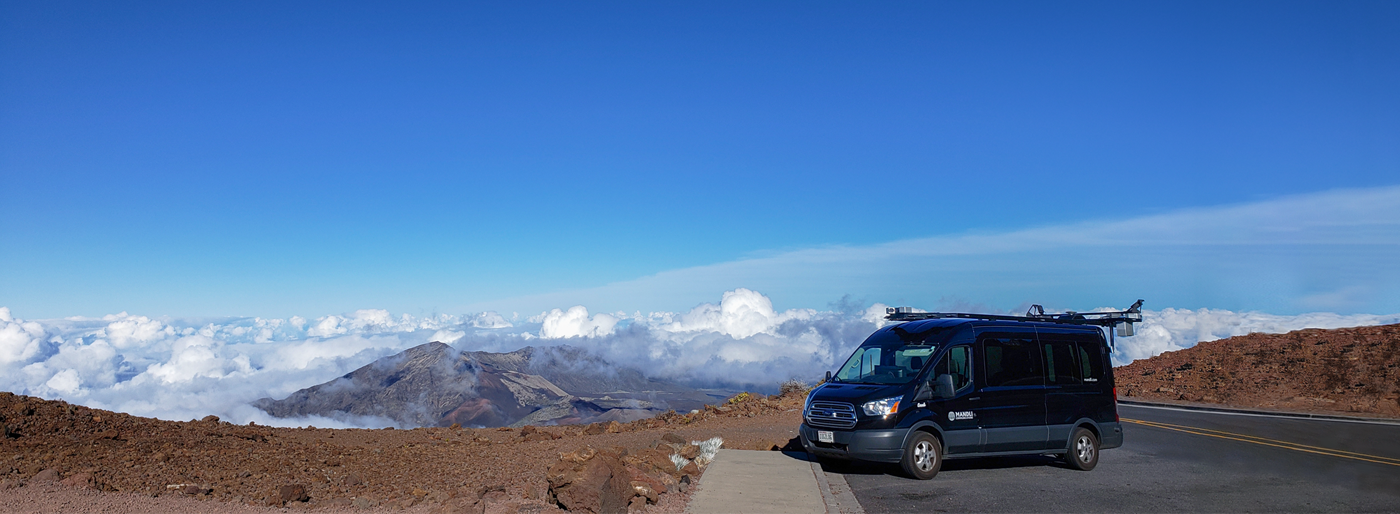
About Mandli Communications
Based in Madison, Wisconsin, Mandli is an industry leader in specialized highway data collection and the integration of 3D pavement technology, mobile LiDAR, and geospatial data collection equipment for various Departments of Transportation throughout the United States. Together with a suite of supporting GIS software and services, Mandli has enabled their clients to design, manage and maintain safe and efficient transportation infrastructure networks.
Since 1983, Mandli has worked with over 30 states across the country, and has brought technology solutions to several nations outside of the U.S. Mandli functions exclusively from the Wisconsin office, and all data is processed and reduced in-house.
3D Pavement Technology
Data Collection
Mobile LiDAR
Our History
Mandli Communications was formed on the first day of the state wrestling tournament in 1983. At the time, no recording devices were allowed in the field house. Ray Mandli secured a contract with the WIAA to film and sell all matches. From there, Mandli began converting film to videodisc, which opened the company to begin working with DOTs.
In 1985, Mandli began transferring Wisconsin DOT’s film to videodisc. This enabled them to tie their photolog to a computer application and to their maps, allowing random access to any point on a road.
In 1988, Mandli built their first photolog van for the Iowa Department of Transportation. It recorded the video images directly to analog optical discs inside the van, which eliminated the conversion of 35mm film to analog disc.
In 1990, Mandli integrated their own proprietary GPS and inertial system into the Arizona DOT’s photolog vehicle. This tagged every image with a linear reference mileage and a GPS point.
Mandli was the first company to produce a real-time digital collection vehicle, which saved the images from a digital camera directly to a hard drive.
Mandli saw a lack of multifunctional vehicles and decided to start integrating pavement systems onto our photolog vehicles. The first pavement technology Mandli integrated was a state-of-the-art line scan pavement profiling system from Phoenix Scientific.
Leading up to 2004, there was a big push in the industry for accurate bridge permitting. Mandli began using a three-laser system (one pointed at the pavement, two pointed up to the overhead structure) to measure vertical clearances.
Up until this point, pavement distress was collected via windshield survey or area scan cameras pointed down at the pavement. To get a better view of the pavement, Mandli developed the linescan system, which integrated two linescan cameras with laser illumination, allowing for continuous pavement imaging.
In the pursuit for better asset inventory and vertical clearance measurements, Mandli came upon Velodyne LiDAR. Mandli integrated Velodyne LiDAR to create high-resolution 3D pointclouds, which gave the ability to identify and extract a wide variety of assets, and perform horizontal and vertical clearance measurements in one pass of the collection vehicle.
- 150,000 Miles Collected
- 1,000,000 Assets Extracted
- First solid model from LiDAR used in a commercial
In 2012, Mandli made the switch from 2D to 3D pavement profiling with the LCMS. This increased accuracy and allowed for the development of automated distress.
- 100,000+ miles of roadway scanned
- 215+ terabytes of data collected
- 1,110,000+ assets extracted
In 2016, Mandli introduced the Maverick, an ultra-portable mobile mapping system that combines high-resolution 360º imaging, high-definition LiDAR, and an integrated position and orientation system, to provide a robust and multi-functional dataset.
Mandli introduced its newest Data Collection Vehicle, the X35 in 2018. Equipped with the latest technology for pavement scanning and LiDAR for asset information, the X35 comes with 9 cameras, each with a resolution of 80 megapixels per image, at rates up to 500 frames per mile, and provides 360-degree image coverage.
In 2019, Mandli achieved the unique distinction of being the first technology company to get its data collection vehicle certified at the National Center for Asphalt Technology (NCAT) for two of its pavement scanning systems, LCMS-1 and LCMS-2.
Mandli delivered the first Highly Automated Driving (HAD) Map to a client for testing autonomous vehicles (AVs). What sets Mandli apart in HAD map development is our ability to create customized maps for any given location.


Portable

Powerful

Proven

Planetary
Maverick is a portable, powerful, and proven spatial data collection system. Combining high-resolution 360º imaging, high-definition LiDAR, and an integrated position and orientation system, Maverick is capable of efficient and accurate mobile data collection. The portable system is able to operate in a wide range of conditions and can be utilized for projects of any size and scope.
System operation is simple and intuitive, requiring only one person to collect and review the data. The included collection software features real-time component feedback and data viewing functionality, allowing for data to be easily collected and quality checked in-field. Maverick also comes packaged with robust viewing and asset management software for putting your data to use.
For more information about Maverick, email maverick@mandli.com. For information about our other services, email info@mandli.com.
Learn More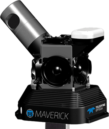
Featured Case Studies
Click on a case study icon below to learn more about that study.

Mandli: the leader in mobile data collection.