Vehicle Builds

For Departments of Transportation, making cost-effective and timely decisions on roads and highways comes down to having access to accurate roadway data. Mandli Communications can help by providing vehicles that collect accurate and efficient highway data.
We provide real-world solutions to the challenging task of collecting pavement and roadway asset information that directly affects budget and maintenance decisions.
Mandli Vehicles Offer:

A Customizable Solution
Mandli builds roadway data collection vehicles to be modular and customizable. In addition to customizing the van make, model, and color, all system components (such as LiDAR sensors, LCMS pods, or cameras) can be easily added or removed. This ensures simple customization or easy repairs when necessary.
The Advantages of a Systems Integrator
Mandli provides our clients with the best technology that’s available. This means the highest resolution imaging, the most accurate GPS, and pavement scanning systems that offer the most accurate and repeatable data. Mandli has the advantage of being able to add or remove specific systems as technology changes. This flexibility means we test and evaluate new technology and add them to our vehicles to give you the most advanced toolset for collecting roadway data.

Industry-Leading Technology

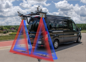
 Right-of-Way Imaging – Mandli vehicles come equipped with 4096x2160-pixel (8.9 megapixels per image) resolution camera systems. Our standard camera configuration is nine cameras: three forward-facing and six side/rear-facing. Though this configuration is customizable, we recommend nine cameras to provide 360° coverage, ensuring you can inspect the infrastructure from more angles compared to traditional ROW imaging, and that you get the most information from your dataset in a cost-efficient way.

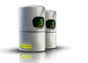
 Laser Crack Measurement System (LCMS-2) – Mandli built vehicles collect pavement distresses, rutting, raveling, faulting, macrotexture, pavement images, and International Roughness Index (IRI) data. Mandli’s pavement scanning technology is capable of operating in all lighting conditions and on various pavement types ranging from dark asphalt to concrete. It also meets the AASHTO R56 requirement per NCAT and is HPMS compliant.

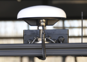 Position Orientation System – Mandli equips our vehicles with the iXblue ATLANS-C system, a high-performance all-in-one position and orientation system (POS) that collects vehicle position, velocity, altitude, track, speed, and dynamics from the moving vehicle. Additionally, it provides extremely robust continuous positioning in urban environments, where GNSS signals can be obscured, intermittent, or possibly distorted by multi-path/reflective surfaces.

 Mobile Mapping System – Mandli vehicles have the option to come equipped with our Mobile Mapping System that integrates dual Velodyne HDL-32 Light Detection and Ranging technology (LiDAR) sensor technology for roadway asset collection. The Mobile Mapping System allows for complete data acquisition of roadway features in a single pass at highway speeds, ensuring the vehicles don’t interfere with the flow of traffic.

A Proven Solution
Vehicles we build for our clients use the same technology Mandli uses for its own collection vehicles. This means the systems have been subjected to rigorous testing and collection schedules. We use the feedback from our collection crews to improve the layout and use of space within the vehicle, and we make sure that the crew can operate and spend a long time within the vehicle comfortably. This process ensures that these systems not only produce accurate and repeatable data but that they can withstand the requirements of a network-level data collection project.
For more information on how Mandli can customize a solution to fit your data collection needs, please reach out to one of our representatives for more information.